Magdalene Bridge spans the River Cherwell east of Oxford’s uk/local/city-centre/">city centre and links the High Street with Magdalen College grounds and the meadows.
- What is Magdalene Bridge?
- When was Magdalene Bridge built and altered?
- Why is Magdalene Bridge historically significant?
- What are the architectural components of Magdalene Bridge?
- How does Magdalene Bridge relate to river management and punting?
- What real-world uses and activities occur at Magdalene Bridge?
- What data or statistics describe Magdalene Bridge usage and condition?
- How does Magdalene Bridge affect urban planning and heritage management?
- What future relevance does Magdalene Bridge hold?
- What are authoritative sources for further verification?
What is Magdalene Bridge?
Magdalene Bridge is a stone road bridge crossing the River Cherwell adjacent to Magdalen College, built in 1772 and rebuilt with widened parapets in 1882.
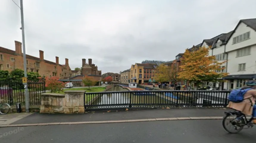
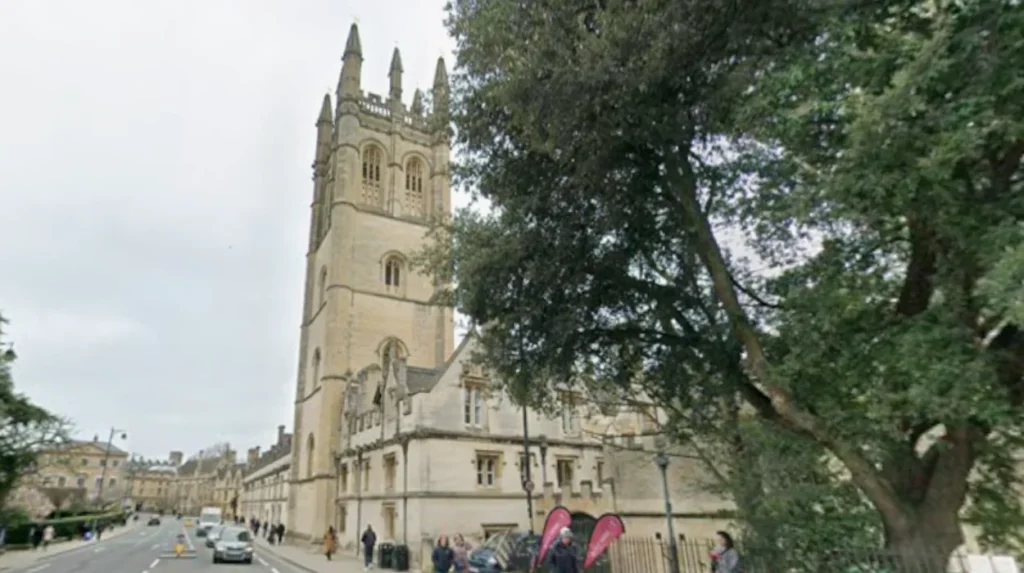
Magdalene Bridge is a multi-arch stone structure sited immediately east of Oxford’s city centre where the High Street meets the southern edge of Magdalen College grounds. The bridge carries vehicle and pedestrian traffic and provides a principal access route between central Oxford and the eastern meadows. The name derives from Magdalen College, a constituent college of the University of Oxford founded in 1458; the college name references Mary Magdalen, a Biblical figure. The bridge’s masonry, alignment, and proximity to the college and to the River Cherwell make it a prominent urban and visual landmark.
When was Magdalene Bridge built and altered?
The current stone bridge dates to 1772; substantial repairs and parapet widening occurred in 1882, with earlier wooden and medieval crossings at the site.
Historical records show successive crossings at this location: medieval timber or simple stonework gave way to an 18th‑century stone rebuild completed in 1772. The 1772 structure replaced earlier bridges documented in city records and maps; the 19th‑century works modified parapets and approach alignments to accommodate increased traffic and carriage use. Archaeological and archival sources record incremental interventions rather than a single modern replacement, so fabric from several periods survives in foundations and spandrels. The bridge’s recorded dates establish its primary 18th‑century origin and Victorian-era modifications.
Why is Magdalene Bridge historically significant?
Magdalene Bridge anchors Oxford’s eastern approach and frames centuries of academic, civic, and social activity tied to Magdalen College and the Cherwell meadows.
The bridge’s significance arises from its role in movement, collegiate ritual, and riverside leisure. It physically connects the academic precinct (Magdalen College) with the city’s commercial street pattern and with open parkland known as Christ Church Meadow and the Cherwell floodplain. The bridge features in local traditions, including seasonal gatherings and processions historically tied to college ceremonies. Its visual relationship with Magdalen Tower and college buildings contributes to Oxford’s registered historic townscape and to tourism circulation patterns documented by local heritage groups.
What are the architectural components of Magdalene Bridge?
Magdalene Bridge has multiple stone arches, spandrels, dressed ashlar parapets, and a paved carriageway with pedestrian walkways on either side.
Architecturally, the bridge comprises several semicircular arches supported on piers that divide and channel sections of the Cherwell; the arches sit on substantial cut-stone abutments and wingwalls. The parapets are dressed ashlar stone, originally narrower before 19th‑century widening works. The carriageway historically accommodated horse traffic and later motor vehicles; footpaths flank the roadway for pedestrians. Drainage outlets and scour protection at pier bases reflect practical hydraulic responses incorporated during repairs. The composition reflects functional bridge engineering of the late 18th century with Victorian refinements.
How does Magdalene Bridge relate to river management and punting?
Magdalene Bridge sits above a navigable stretch of the Cherwell used for recreational punting and acts as a hydraulic constriction influencing local flow and flood risk.
The River Cherwell under the bridge supports recreational boating—particularly punting from boathouses located downstream of the bridge—and the bridge’s openings shape flow velocities and water levels during high discharge. Local water management agencies and college boathouses monitor the channel and maintain launching points near the bridge. The bridge’s piers create localized turbulence that operators consider when navigating punts; seasonal flow variations affect when punting is safe. The bridge therefore functions within both transport and leisure systems on the Cherwell.
What real-world uses and activities occur at Magdalene Bridge?
Magdalene Bridge is used daily for vehicle and pedestrian movement and as a viewpoint and starting point for punting, walking, and photographic tourism.
Residents, students, and visitors use the crossing to commute between the High Street and eastern neighborhoods or to access Magdalen College and riverside meadows. Tour operators include the bridge on walking routes for its views of Magdalen Tower, the college chapel, and the Cherwell’s tree-lined banks. The adjacent meadows host seasonal events and recreational walking; the bridge often forms a visual nucleus for these activities. Punting operators rent boats from boathouses downstream, using the bridge area as a common reference for pick-up and drop-off.
What data or statistics describe Magdalene Bridge usage and condition?
Local transport surveys record pedestrian flows and vehicle counts at central crossings; conservation records list the bridge as an 18th‑century structure requiring periodic masonry repair.
Municipal traffic counts for central Oxford measure daily pedestrian and vehicle passages across principal bridges, with peak pedestrian volumes during university term times and tourist seasons. Heritage conservation reports classify the bridge as an historic crossing, requiring structural inspections and masonry maintenance every 5–15 years depending on condition. Flood records for the Cherwell identify the bridge zone as part of a floodplain system that registers high-water events during heavy rainfall, triggering environment‑agency monitoring and temporary access restrictions. These operational data inform maintenance cycles and public-safety measures.
How does Magdalene Bridge affect urban planning and heritage management?
Magdalene Bridge constrains route design, informs conservation zoning, and shapes public realm decisions for the eastern High Street and meadow edges.
Planning authorities treat the bridge and adjacent historic assets as part of a conservation area where alterations require listed-building or planning consents. The bridge’s presence influences traffic-calming schemes, pedestrian priority measures, and signage to protect heritage views toward Magdalen Tower. Landscape and floodplain management plans consider the bridge when designing cycle routes, riverside landscaping, and riparian habitat interventions to reconcile access with ecological sensitivity. Heritage managers balance structural preservation with the need for safe, accessible crossings.
What future relevance does Magdalene Bridge hold?
Magdalene Bridge will remain a permanent transport and heritage asset for Oxford, requiring ongoing maintenance, flood resilience measures, and integration into pedestrian-first city plans.
Projected urban policies prioritise reduced motor traffic in central Oxford and enhanced walking and cycling routes; the bridge will be evaluated for accessibility upgrades compatible with its historic fabric. Climate-change projections that increase extreme rainfall events make flood-resilience work at bridge approaches and riverbanks more urgent. Conservation-led maintenance will continue to preserve stonework while adapting parapets, surfacing, and drainage systems to modern safety standards. The bridge’s cultural and visual importance ensures it remains a focus of heritage and transport strategy.
What are authoritative sources for further verification?
Primary verification sources include local heritage records, university college archives, and municipal transport or conservation reports that document the bridge’s history and condition.
Useful sources for citation and fact-checking are the bridge entry in historic building registers, the Magdalen College archival records that trace the college–bridge relationship, city council conservation area appraisals that cover eastern High Street structures, and river‑management documentation held by local environment or waterways trusts. These institutional records provide building dates, repair histories, and planning constraints. Consult these repositories for manuscript-level evidence and technical reports.