The River Cherwell is a 40-mile (64-kilometre) tributary of the River Thames in central England. It rises in the ironstone hills near Hellidon, Northamptonshire, and flows south through Oxfordshire before joining the Thames in Oxford. The riverside Cherwell path follows the river through the city, connecting Oxford University Parks, Marston Meadows, Magdalen College, and Christ Church Meadow across a network of well-established footpaths. The route is one of Oxford’s most used green corridors for walking, cycling, and nature observation, attracting over seven million annual visitors to Oxford’s waterside environments.
- What Is the History of the River Cherwell and Its Riverside Paths?
- Where Does the Riverside Cherwell Path Begin and End?
- What Are the Key Named Walks Along the River Cherwell?
- How Long Is the Riverside Cherwell Path, and What Is the Difficulty Level?
- What Landmarks and Attractions Are Located on the Riverside Cherwell Path?
- What Practical Information Do Walkers Need Before Using the Riverside Cherwell Path?
- How Does the Riverside Cherwell Path Connect to Wider Oxford Walking Routes?
- Is the River Cherwell walk suitable for beginners or families?
- How long does it take to walk the full Riverside Cherwell path?
- Can you cycle along the Riverside Cherwell path?
- What wildlife can you see along the River Cherwell?
- Where is the best starting point for the Riverside Cherwell walk?
What Is the History of the River Cherwell and Its Riverside Paths?
The River Cherwell has shaped human settlement in Oxford for over 2,000 years, forming tribal boundaries, trade routes, and defensive lines before any footpath was formally established. The riverside Cherwell path exists today because the river corridor has been a public right of way since Anglo-Saxon times.
The Cherwell drains a catchment area of 943 square kilometres and carries an average flow rate that increases the Thames discharge from 17.6 cubic metres per second on entry into Oxford to 24.8 cubic metres per second on exit. The river formed the natural boundary between the Dobunni tribe to the west and the Catuvellauni to the east during the Roman period. A Romano-British settlement at what is now central Oxford dominated the regional pottery trade, distributing goods via the Thames and Cherwell waterways. The location of modern Oxford, documented as Oxenaforda, meaning “ford of the oxen” in Anglo-Saxon records, was defined by the convergence of these two rivers.
The Domesday Book of 1086 records manors along the Cherwell, including Shipton-on-Cherwell and Headington, where riverside mills generated agricultural income. In 2023, archaeologists confirmed a Viking sword dated to 850 to 975 AD, retrieved by a magnet fisher from the Cherwell near Enslow. The sword is now conserved at the Oxfordshire Museum and demonstrates the river’s role in preserving Viking-era relics from the region. The riverside walking paths were formalised over centuries as Oxford University colleges expanded their grounds along the riverbanks, creating named walks including Addison’s Walk and the Mesopotamia Walk by the 18th century.
Where Does the Riverside Cherwell Path Begin and End?
The most commonly walked section of the Riverside Cherwell path begins at Rainbow Bridge inside Oxford University Parks and ends at Magdalen Bridge near the city centre, covering approximately 2.5 miles one way. The full circular route, including Marston, covers 4.6 miles and returns walkers to their starting point.
Rainbow Bridge, formally known as High Bridge, is a curved footbridge over the River Cherwell inside the University Parks, located northeast of Oxford city centre. The University Parks cover approximately 70 acres and are bordered by the River Cherwell on their eastern boundary. Walking north from Rainbow Bridge along the east bank, the path passes Wolfson College, one of the constituent colleges of the University of Oxford, followed by Lady Margaret Hall on the opposite bank.
A footbridge at Wolfson College gives access to the college grounds and a connecting route back into the city. Continuing north, walkers reach the Victoria Arms pub, locally called the Vicky Arms, at the Marston Ferry Road junction. The southern end of the main walking route reaches Magdalen Bridge, where the river passes beneath the medieval stone bridge on the High Street. Just south of Magdalen Bridge, the Cherwell splits into two branches and flows around Christ Church Meadow before entering the Thames. The section between Magdalen Bridge and Christ Church Meadow adds a further 0.5 miles to any southern extension of the walk.
What Are the Key Named Walks Along the River Cherwell?
The riverside Cherwell path incorporates four named walking routes: Addison’s Walk, Mesopotamia Walk, the University Parks riverside path, and the Christ Church Meadow walk. Each occupies a distinct geographical segment of the river corridor.
LegesRomanorum
Addison’s Walk is accessible from Magdalen College and follows a loop around a small island formed by two branches of the Cherwell. The walk is named after Joseph Addison, the 18th-century essayist and fellow of Magdalen College. The path is approximately one mile in circumference and passes through ancient meadowland where 35 species of wildflower have been recorded, including fritillaries. Mesopotamia Walk runs parallel to Addison’s Walk, slightly to the north, and connects the University Parks with Marston Road.
Its name refers to the island-like strip of land between two branches of the Cherwell, directly mirroring the ancient Greek name for the land between the Tigris and Euphrates rivers. The University Parks riverside path follows the Cherwell along the park’s eastern edge from Rainbow Bridge south to the Cherwell Boathouse, a distance of roughly 0.7 miles. Cycling is not permitted inside the University Parks. The Christ Church Meadow walk runs along the western bank of the Cherwell, offering views across meadowland grazed by longhorn cattle. Christ Church Meadow is owned and maintained by Christ Church College and is open to the public during daylight hours throughout the year.
How Long Is the Riverside Cherwell Path, and What Is the Difficulty Level?
The main circular Riverside Cherwell path covers 4.6 miles (7.4 kilometres) with a total ascent of approximately 72 feet, making it a flat route suitable for walkers of all fitness levels. The terrain is mostly level with sections of compacted path, grass, and occasional uneven ground near riverbanks.
The route from Rainbow Bridge north to the Victoria Arms and east through Marston before returning south through the meadows is the standard circular format. Total walking time at a moderate pace is approximately 1.5 to 2 hours. The southern extension to Magdalen Bridge adds 30 to 40 minutes to any outing. The path is well maintained through the University Parks and along Christ Church Meadow, with a surface quality high enough for walking and light jogging.
Sections east of Wolfson College toward Marston become muddy during wet weather, particularly in the winter months between November and February. Oxford City Council designates parts of the route as suitable for prams and pushchairs, though the Marston meadow section requires care in wet conditions. Cyclists are permitted on the Marston Ferry Road Bridge section and on paths north of the University Parks, but must dismount inside the parks themselves. The riverside Cherwell path is classified as an easy trail on established walking databases, requiring no specialist equipment or prior navigation experience.
What Wildlife and Natural Features Can Be Seen Along the Riverside Cherwell Path?
The riverside Cherwell path passes through habitats supporting 36 Sites of Special Scientific Interest along the full river corridor, including meadows, wetlands, and riparian woodland that support diverse flora and fauna year-round. Specific wildlife observable along the Oxford section includes kingfishers, red kites, grey herons, water voles, and multiple bat species active at dusk.
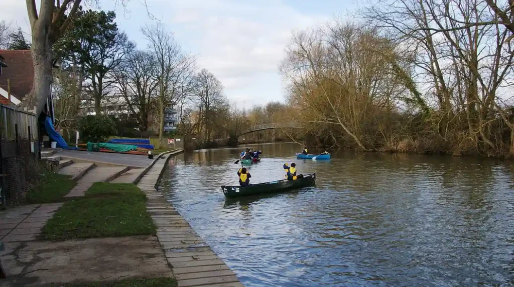
The Wolfson College Nature Reserve borders the east bank of the Cherwell near the northern extent of the Oxford path. The meadows in this area carry SSSI designation and are maintained as a working farm by the college. Red kites are a regular sighting across the Oxford stretch, having recolonised the region following a successful reintroduction programme in the Chilterns during the 1990s. The river itself supports roach, perch, pike, and bream. Addison’s Walk meadow is documented for 35 wildflower species, including fritillaries, which bloom each April. The Cherwell Boathouse, located just north of the University Parks, is the primary hire point for punts. Punts are flat-bottomed boats propelled by a pole pushed against the riverbed and are available for hire from April through October each year. The river’s willow-fringed banks in Oxford were identified by literary scholars as a direct inspiration for J.R.R. Tolkien’s Withywindle river in The Lord of the Rings, written between 1937 and 1949. Scholar Tom Shippey traced the Withywindle’s name to Old English elements meaning “willow-stream,” directly mirroring the Cherwell’s character.
What Landmarks and Attractions Are Located on the Riverside Cherwell Path?
The Riverside Cherwell path passes seven significant landmarks within the Oxford city boundary: Rainbow Bridge, Wolfson College, Lady Margaret Hall, Cherwell Boathouse, Magdalen College, Oxford Botanic Garden, and Christ Church Meadow. Each landmark is accessible directly from the path without detour.
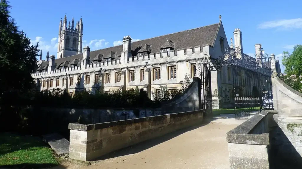
Rainbow Bridge is the most photographed structure on the route, recognisable by its distinctive curved arch. Wolfson College, a graduate college of the University of Oxford with particular academic strengths in global health and environmental studies, sits directly on the east bank and is accessible via a footbridge from the path. Lady Margaret Hall, located on Norham Gardens overlooking the Cherwell and adjacent to the University Parks, was one of Oxford’s originally single-sex colleges.
The Cherwell Boathouse operates as both a punt hire station and a riverside restaurant, making it a natural rest and refreshment point mid-walk. Magdalen Bridge, constructed in its current stone form in 1782, marks the river’s entry into the city’s historic core. Each year on 1 May, Oxford students traditionally jump from the bridge into the river, a practice that authorities describe as hazardous when river levels are low. The Oxford Botanic Garden, founded in 1621 and the oldest botanic garden in Britain, is situated immediately west of the Cherwell at Magdalen Bridge. Christ Church Meadow, at the southern end of the walk, provides direct views of Christ Church College’s rear facades, recognised internationally from the Harry Potter film series.
What Practical Information Do Walkers Need Before Using the Riverside Cherwell Path?
The Riverside Cherwell path is free to access, open year-round during daylight hours, and reachable from Oxford city centre within a 10-minute walk. No registration, permit, or booking is required for any public footpath section of the route.
The primary access points are Rose Lane off the High Street for Christ Church Meadow, the University Parks entrance on Parks Road for the Rainbow Bridge start, and Marston Ferry Road for mid-route access. Oxford city centre connects to the route via multiple bus and cycle routes. Oxford Railway Station sits approximately 1.2 miles from the University Parks entrance. Parking near the route is limited. The University Parks have no dedicated car park, and on-street parking in North Oxford requires either a resident permit or a paid space. Sections near Marston and Christ Church Meadow are subject to seasonal flooding, and Oxford City Council issues closure notices during high-water events with signage at flood-prone entry points. Dogs are permitted on public footpath sections but face seasonal restrictions in meadow areas where livestock graze. Cyclists must dismount within the University Parks and slow to pedestrian pace on shared narrow sections near Magdalen Bridge and Christ Church Meadow.
How Does the Riverside Cherwell Path Connect to Wider Oxford Walking Routes?
The Riverside Cherwell path connects directly to the Thames Path National Trail, the Oxford Canal walking route, and the Port Meadow walking network, creating a continuous 15-plus-mile system of traffic-free walking and cycling routes through Oxford. These connections make the Cherwell corridor a central component of Oxford’s active travel infrastructure.
The Thames Path National Trail is a 183-mile route from the Cotswolds to London. It joins the Cherwell path at Christ Church Meadow, where the two rivers converge near Iffley Fields. Walking north from the Cherwell path via the Marston Ferry Road crossing connects walkers to Cutteslowe Park, a public park with recreational facilities 1.5 miles north of the University Parks. National Cycle Route 51, managed by Sustrans, follows roads parallel to the Cherwell north toward Bicester, offering cyclists a longer-distance corridor alongside the river valley. National Cycle Route 5 runs from Oxford to Banbury, a 34-mile corridor through Oxfordshire that passes through the wider Cherwell Valley and past Blenheim Palace.
Oxford City Council’s waterway walking network also includes the Oxford Canal path, which begins at Hythe Bridge near the railway station and runs north for 78 miles to Coventry, connecting the Thames to the Midlands canal network. Together, the Cherwell, Thames, and Canal paths give Oxford one of the most extensive urban riverside walking and cycling networks in England, linking green spaces, nature reserves, university buildings, and historic sites without requiring walkers to use roads.
Is the River Cherwell walk suitable for beginners or families?
Yes, the Riverside Cherwell path is an easy, mostly flat route with very little elevation. Sections through University Parks and Christ Church Meadow are well-maintained and ideal for families. Just be cautious of muddy patches during the winter months.
How long does it take to walk the full Riverside Cherwell path?
The main circular route (about 4.6 miles) takes around 1.5 to 2 hours at a moderate pace. If you extend your walk toward Magdalen Bridge, it can add another 30–40 minutes. Taking breaks for views or photos may increase the total time.
Can you cycle along the Riverside Cherwell path?
Cycling is partially allowed, but not inside University Parks, where cyclists must dismount. Northern sections and areas near Marston allow cycling, but paths can be narrow, so riders should give priority to pedestrians.
What wildlife can you see along the River Cherwell?
The area supports diverse wildlife including kingfishers, red kites, grey herons, and water voles. Around Addison’s Walk, you can also see seasonal wildflowers like fritillaries in spring. Early mornings and evenings are best for spotting animals.
Where is the best starting point for the Riverside Cherwell walk?
Most visitors start at Rainbow Bridge, which is central and easy to access. Other entry points include Marston Ferry Road and Christ Church Meadow. Your starting point depends on how long you want your walk to be.