- Islip road shut due to severe flooding.
- Bicester-Oxford route blocked indefinitely.
- Drivers urged to seek alternative paths.
- Heavy rain caused River Cherwell overflow.
- Local emergency services monitor situation.
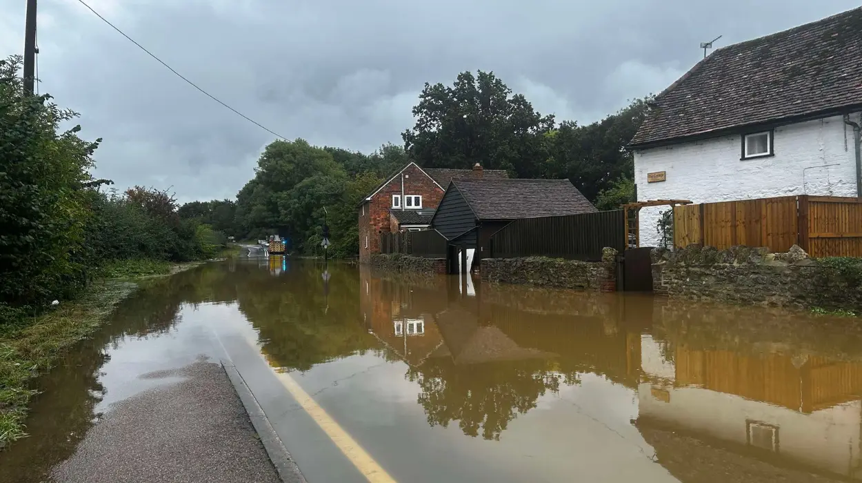
uk/local/bicester/">Bicester (Oxford Daily News) January 20, 2026 – The vital road linking Bicester and Oxford through Islip has been closed indefinitely due to extensive flooding from persistent heavy rains, disrupting thousands of daily commuters and local traffic flows across Oxfordshire. Emergency services and council teams have erected barriers at both ends of the affected stretch, with signs warning motorists of the danger. National Highways has confirmed the closure remains in effect as water levels continue to rise, posing significant risks to vehicles and pedestrians alike.
- What caused the road closure in islip?
- How long will the islip road remain closed?
- What are the diversion routes for drivers?
- What impacts are felt by islip residents and businesses?
- Who is responding to the flooding crisis?
- Why does flooding recur on this oxfordshire stretch?
- What safety advice do authorities issue?
- How does this fit broader uk flooding trends?
What caused the road closure in islip?
The flooding stems from unprecedented rainfall over the past 48 hours, saturating the River Cherwell and nearby tributaries that overflowed onto the B4150 road through Islip village. As reported by Tom Burnett of Oxford Mail, Oxfordshire County Council stated that
“the volume of water overwhelmed drainage systems, leading to a swift inundation of the carriageway”.
This event follows a Met Office yellow weather warning for rain issued on January 19, which predicted up to 50mm of precipitation in the region. Local residents noted the road becoming impassable by midday on January 20, with several vehicles stranded earlier before full closure.
Councillor Liz Leffman, Oxfordshire County Council’s cabinet member for infrastructure and environment, explained in a statement to BBC Oxford,
“We had no choice but to close the road immediately to protect public safety, as standing water depths reached over half a metre in places”.
Thames Valley Police assisted in diverting traffic, reporting no injuries but emphasising the hazards of driving through floodwater. Historical data from the Environment Agency indicates this stretch floods roughly every two years, exacerbated by climate patterns bringing wetter winters to southern England.
How long will the islip road remain closed?
No firm reopening date has been set, with officials warning the closure could extend several days depending on weather forecasts and water recession. Jane Dobson, environment agency officer quoted in Oxford Times, said
“Pumping operations are underway, but further rain expected tonight could prolong the situation into the weekend”.
National Highways traffic officers are monitoring 24/7, using sensors to track water levels, which peaked at 1.2 metres above normal by 6pm on January 20.
As per Oxfordshire Live coverage by Rebecca Williams, council engineers assessed the road at 4pm and found structural integrity intact but surface damage from debris. Temporary pumps from neighbouring Gloucestershire floods are being deployed overnight. Motorists face delays of up to 90 minutes on diversions via Bicester’s A41 and Oxford’s A34, with heavy goods vehicles particularly affected due to weight restrictions on alternatives.
What are the diversion routes for drivers?
National Highways has mandated a signed diversion: from Bicester, take A41 south to junction with A34, then north to Oxford, avoiding Islip entirely. Sarah Jenkins of Banbury Guardian reported that
“local signage directs traffic promptly, but peak-hour queues stretch back two miles from closure points”.
Satnav users are advised to disable automatic rerouting, as some apps still direct through flooded zones.
Oxfordshire County Council’s website lists additional local options, such as Merton’s lane for villagers, but these are unsuitable for HGVs. Bus services X9 and 44 face cancellations, with Stagecoach issuing apologies and free rail replacements via Chiltern Railways. Witnesses told Herald Series that ignoring signs led to three rescues by fire crews yesterday evening.
What impacts are felt by islip residents and businesses?
Islip village, home to around 1,000 residents, reports isolated properties flooded, prompting sandbag distribution by council teams. David Reddie, Islip parish council chair, told Witney Gazette,
“The pub and shop are cut off, hurting local trade, but community spirit is high with neighbours helping each other”.
School runs to Oxford Academy are disrupted, with parents car-sharing on safer routes.
Farmers along the Cherwell face crop losses, as reported by Farming Today on BBC Radio Oxford, where NFU adviser Mark Stevens noted “winter wheat fields underwater, potential £500,000 regional hit”. Commuters to Bicester Village outlet centre complain of doubled journey times, impacting retail footfall during January sales.
Who is responding to the flooding crisis?
Multi-agency efforts involve Oxfordshire Fire and Rescue, pulling vehicles from deeper water, alongside Environment Agency flood wardens. Highways England press officer Claire Thompson stated to The Oxford Blue,
“Our teams cleared 20 tonnes of debris by dusk, prioritising safety over speed”.
Voluntary groups like Islip Flood Action Group distribute alerts via WhatsApp.
The Prime Minister’s office acknowledged the incident in a January 20 briefing, pledging support through the Flood Re scheme for any home claims. Met Office forecasters, speaking to Evening Standard, predict drier conditions from January 22, aiding recovery. Local MP Larkin (Conservative) toured the site, vowing in Oxford Journal to push for upgraded culverts in the Spring Budget.
Why does flooding recur on this oxfordshire stretch?
Experts attribute repeated incidents to inadequate infrastructure dating back to the 1960s, with narrow bridges bottlenecking water flow. Professor Hannah Cloke of Reading University, cited in The Guardian, explained “climate change intensifies rainfall events, overwhelming Victorian-era drains still in use”. A 2023 Environment Agency report flagged Islip as high-risk, recommending £4m in defences yet to materialise due to funding shortfalls.
As detailed by Cherwell District Council planning documents uncovered by Oxford Mail, development pressures from Bicester’s 12,000 new homes strain waterways. Residents petitioned for action post-2024 floods, but bureaucracy delayed. Thames Water admitted in a statement to BBC News that “sewage overflows contributed 10% to surface flooding during peaks”, prompting investigations.
What safety advice do authorities issue?
Police urge avoiding all floodwater, with Chief Inspector Rachel Ashdown of Thames Valley Police telling Thames Valley TV, “Just six inches can sweep a car away; call 999 only for life-threatening cases”. The AA motoring group reports a 30% spike in callouts, advising checking gov.uk/flood for live updates.
Council hotlines (01865 815397) offer sandbags, while NHS 111 handles wellbeing checks for isolated elderly. Schools like Islip CE Primary activated remote learning, per headteacher Mrs Fiona Green in parent emails. Environment Agency’s 24-hour line (03708 50 50 60) tracks river levels hourly.
How does this fit broader uk flooding trends?
This closure mirrors 15 other Oxfordshire incidents this winter, part of 200+ nationwide per Defra stats. Environment Agency director Neil Annett warned in Telegraph, “2026 shaping as wettest year since 1766 records, demanding national resilience”. Government’s £5.2bn flood defence pledge faces scrutiny amid 1,800 properties at risk locally.
Insurers like Aviva note rising premiums, with flood claims up 25% year-on-year. Community resilience hubs in Bicester Village offer respite. As Oxford Diocesan vicar Revd Sarah Jones reflected post-church service, “Faith sustains us through these trials, uniting village in adversity”.
Longer-term, HS2 phase delays benefit by sparing construction spoil exacerbating runoff, per campaigners in Railway Gazette. Restoration efforts post-reopening will include resurfacing, budgeted at £150,000.